Complete ecotouristic information database on national parks of Java (Indonesia).
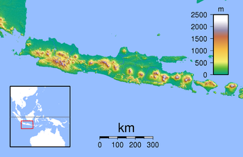
The area of this island is approximately 139,000 km2. Java lies between Sumatra to the west and Bali to  the east. Java is surrounded by Java Sea in the north, Sunda Strait in the west, Indian Ocean in the south and Bali Strait and Madura Strait in the east. With a population of 135 million Java is the world's most populous island, and one of the most densely-populated places on the globe. The Indonesian capital city, Jakarta, is located in western part of Java.
Formed mostly as the result of volcanic eruptions, Java is the 13th largest island in the world and the fifth largest island in Indonesia. A chain of volcanic mountains forms an east-west spine along the island. It contains thirty-eight volcanoes. The highest volcano in Java is Mount Semeru (3,676 m). The most active volcano in Java and also in Indonesia is Mount Merapi (2,968 m). The island's longest river is the 600 km long Solo River. The river rises from its source in central Java at the Lawu volcano.
Temperatures throughout the year average 22°C to 29°C and humidity average 75%. The northern coastal plains are normally hotter. The south coast is generally cooler than the north, and highland areas inland are cooler again. The wet season begins in October ending in April. The wettest months are January and February.
Despite to high human population density there are several interesting national parks to be visited.
Detailed information on Java (Indonesia) national parks.
There is a database of Java national parks available. If you have any question or request you can send it by attached Informative Form.