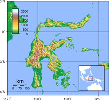
Complete ecotouristic information database on national parks of Sulawesi (Indonesia).
Sulawesi is one of the four Greater Sunda Islands, and the world's eleventh-largest island covering an area of 174,600 km2. It is situated between Borneo and the Maluku Islands. In Indonesia, only Sumatra, Borneo, and Papua are larger in territory, and only Java and Sumatra have larger populations.
Sulawesi comprises four peninsulas: the northern Minahasa Peninsula; the East Peninsula; the South Peninsula; and the South-east Peninsula. Three gulfs separate these peninsulas: the Gulf of Tomini between northern Minahasa peninsula and East Peninsula; the Tolo Gulf between East and Southeast Peninsula; and the Bone Gulf between the South and Southeast Peninsula. The Strait of Makassar runs along the western side of the island and separates the island from Borneo.
The central part of the island is ruggedly mountainous, such that the island's peninsulas have traditionally been remote from each other, with better connections by sea than by road. The island slopes up from the shores of the deep seas surrounding the island to a high, mostly non-volcanic, mountainous interior. Active volcanoes are found in the northern Minahassa Peninsula.
By the 2010 Census the total had reached 17,371,782, and the latest official estimate (for January 2014) is 18,455,058. The largest city is Makassar.
Sulawesi is part of Wallacea, meaning that it has a mix of both Asian and Australasian fauna and flora species. The island of Sulawesi has six national parks and nineteen nature reserves. In addition, Sulawesi has three marine protected areas. Many of Sulawesi's parks are threatened by logging, mining, and deforestation for agriculture.
Detailed information on Sulawesi (Indonesia) national parks.
There is a database of Sulawesi national parks available. If you have any question or request you can send it by attached Informative Form.