Complete ecotouristic information database on national parks of Venezuela.
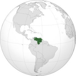
Venezuela is a country on the northern coast of South America. Venezuela's territory covers around  916,445 square kilometres with an estimated population of approximately 29,100,000. Its area makes it the 33rd largest country. Venezuela is considered a state with extremely high biodiversity, with habitats ranging from the Andes mountains in the west to the Amazon Basin rainforest in the south, via extensive llanos plains and Caribbean coast in the center and the Orinoco River Delta in the east.
Venezuela borders Colombia to the west, Guyana to the east, and Brazil to the south. Caribbean islands such as Trinidad and Tobago, Grenada, Curaçao and Aruba lie near the Venezuelan coast. Venezuela has territorial disputes with Guyana (formerly United Kingdom), largely concerning the Essequibo area, and with Colombia concerning the Gulf of Venezuela.
Shaped roughly like a triangle, the country has a 2,800 km coastline in the north, which includes numerous islands in the Caribbean Sea, and in the northeast borders the northern Atlantic Ocean. Most observers describe Venezuela in terms of four fairly well-defined topographical regions: the Maracaibo lowlands in the northwest, the northern mountains extending in a broad east-west arc from the Colombian border along the northern Caribbean coast, the wide plains in central Venezuela, and the Guiana Highlands in the southeast.
The northern mountains are the extreme northeastern extensions of South America's Andes mountain range reach. Pico Bolívar, the nation's highest point at 4,979 m, lies in this region. To the south, the dissected Guiana Highlands contains the northern fringes of the Amazon Basin and Angel Falls, the world's highest waterfall as well as tepuis, large table-like mountains. The country's center is characterized by the llanos, which are extensive plains that stretch from the Colombian border in the far west to the Orinoco River delta in the east. The Orinoco, with its rich alluvial soils, binds the largest and most important river system of the country; it originates in one of the largest watersheds in Latin America. The Caroní and the Apure are other major rivers.
Venezuela is entirely located in the tropics over the Equator to around 12° N. Its climate varies from  humid low-elevation plains, where average annual temperatures range as high as 35 °C, to glaciers and highlands (the páramos) with an average yearly temperature of 8 °C. Annual rainfall varies between 430 mm in the semiarid portions of the northwest to over 1,000 mm in the Orinoco Delta of the far east and the Amazonian Jungle in the south. The precipitation level is lower in the period from November to April and later in the year from August to October. These periods are referred to as Hot-Humid and Cold-Dry seasons. Other charasteristic of the climate is this variation throughout the country by the existence of a mountain range called "Cordillera de la Costa" which crosses the country from east to west. The majority of the population lives in these mountains.
Venezuela is among the top twenty countries in terms of endemism. Among its animals, 23% of reptilian and 50% of amphibian species are endemic. Some 38% of the over 21,000 plant species known from Venezuela are unique to the country.
To these unique ecosystems belong for example table mountains that you can see in the south of the country in the Guayana highlands region. Each of these mountains is a world for itself – on its top there exists an absolutely unique ecosystem. You can often find here endemical species – mainly carnivorous plants – that you will not find anywhere else in the world. The same situtation is with other plants and animals – especially the invertebrates. However the climb to the top of these mountains is not without difficulties.
Detailed information on Venezuela National Parks.
There is a database of this country national parks available. If you have any question or request you can send it by attached Informative Form.