Complete ecotouristic information database on national parks of Mongolia.
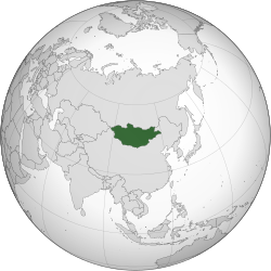
Mongolia is a landlocked country in Central Asia. It is bordered by Russia to the north and China to the  south, east and west. Ulaanbaatar, the capital and also the largest city, is home to about 45% of the population.
At 1,564,116 square kilometres, Mongolia is the 19th largest and the most sparsely populated independent country in the world, with a population of around 2.9 million people. It is also the world's second-largest landlocked country after Kazakhstan. The country contains very little arable land, as much of its area is covered by steppe, with mountains to the north and west and the Gobi Desert to the south.
It mostly lies between latitudes 41° and 52°N (a small area is north of 52°), and longitudes 87° and 120°E. Although Mongolia does not share a border with Kazakhstan, its westernmost point is only 38 kilometres from Kazakhstan.
The geography of Mongolia is varied, with the Gobi Desert to the south and with cold and mountainous regions to the north and west. Much of Mongolia consists of steppes, with forested areas comprising 11.2% of the total land area, a higher percentage than the Republic of Ireland (10%). The highest point in Mongolia is the Khüiten Peak in the Tavan bogd massif in the far west at 4,374 m. The basin of the Uvs Lake, shared with Tuva Republic in Russia, is a natural World Heritage Site. Most of the country is hot in the summer and extremely cold in the winter, with January averages dropping as low as −30 °C. A vast front of cold, heavy, shallow air comes in from Siberia in winter and collects in river valleys and low basins causing very cold temperatures while slopes of mountains are much warmer due to the effects of temperature inversion.
The annual average temperature in Ulaanbaatar is 0°C, making it the world's coldest capital city. Mongolia is high, cold, and windy. It has an extreme continental climate with long, cold winters and short summers, during which most of its annual precipitation falls. The country averages 257 cloudless days a year, and it is usually at the center of a region of high atmospheric pressure. Precipitation is highest in the north (average of 200 to 350 millimeters per year and lowest in the south, which receives 100 to 200 millimeters annually.
There are several beautiful and very interesting national parks in Mongolia. Despite to national parks the is almost intact nature even on the most of Mongolian territory absolutely unique feature at present word conditions. Touristic infrastructure is only poorely developed. Most of expeditions are to be done with 4x4 vehicles, horse, camel or on foot. Accomodation is usually quite simple - tents or jurtas, even when comfortably equipped.
Detailed information on Mongolia National Parks.
There is a database of this country national parks available. If you have any question or request you can send it by attached Informative Form.